Seismology
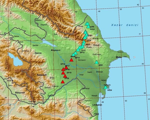
 Studies seismicity on the territory of the republic, kinematic and dynamic parameters of earthquakes. Seismological studies are carried out on the basis of an observation network consisting of 35 seismic stations, the seismic regime of the territory of the republic, the distribution of earthquake sources, the assessment of the dynamics of seismic processes in source zones, the assessment of active sections of deep faults, the intensity of possible maximum earthquakes. The mechanism of strong earthquakes is being studied, the seismic risk of large cities is being assessed, and the seismicity of large construction sites is being studied.
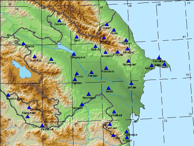
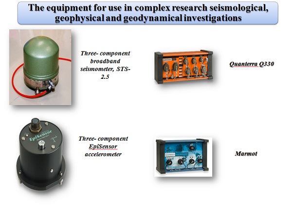
In 2003, the Republican Seismic Survey Center of ANAS began the reconstruction of the seismic monitoring system in the republic. Seismic monitoring is carried out in the districts using telemetry equipment from the US Kinemetrics company.
Bureau of Earthquake Research
The Bureau of Earthquake Research is responsible for analyzing recorded seismic records at seismic stations and determining their kinematic and dynamic parameters.
After a strong earthquake in the Caspian Sea (Baku) (Ml=6.2) on November 25, 2000, by order of the Nationwide Leader Heydar Aliyev, to provide the seismic monitoring network with the most modern devices in Azerbaijan, the American company "Kinemetrics" handed over 14 sets for the RSSC ANAS: a satellite telecommunication system, a digital telemetry seismic station, and since 2003 the monitoring network began its work.
By order of President of the Republic of Azerbaijan Ilham Aliyev, in 2009, the seismic observation network acquired a new software system of two Apple computers and 7 more sets of seismic stations Kinemetrics (USA).
In order to improve the network of seismological observations and scientific research in the field of seismology, in 2009-2010, another 11 Kinemetrics stations were installed. In 2011, RSSC installed and put into operation more than 6 telemetric seismic stations and, thus, the number of seismic stations reached 31.
In 2013, RSSC installed and put into operation four more telemetric seismic stations and thus the number of seismic stations reached 35.
Seismic stations were chosen taking into account the seismicity of certain regions of the territory of Azerbaijan.
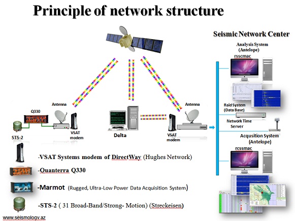
Scheme for receiving data from stations Antelope Real Time update over the years
The Bureau of Earthquake Research processes data on local, near, distant earthquakes, explosions, volcanoes, using 35 telemetry stations located throughout the country. Weak earthquakes are processed by one station (Dbheli program). The earthquake catalog is based on data from telemetry stations. The earthquake source parameters (Tₒ, φ, λ, h and ml) are defined in this catalog.
Areas of seismic activity, epicenter maps, activity maps, earthquake energy distribution, quantity and depth distribution histograms, seismological profiles are studied in ArcGIS, ArcView, Excel, Surfer, PowerPoint programs. Data from mobile stations located in seismically active areas are included in the database and processed.
Seismic tomographic calculations are performed in the Hypoinverse, HypoDD and TomoDD programs. 3D velocity models are built into the Matlab software.
The work schedule of seismic stations of the Center of Seismological Survey of the Nakhchivan Autonomous Republic is controlled and regulated. It also provides data exchange with neighboring countries.
Department of Macroseismic Research
Macroseismic studies are one of the important components of seismological studies and are based on the study of the effects of earthquakes on the earth's surface. These studies allow determining the contours of areas with different intensity values, providing information about the seismic regime, and proposing an idea about the parameters of the earthquake source and the structure of the environment.
Macroseismic data engineering is important during seismology and seismic microzoning work.
The analysis of the data collected as a result of macroseismic observations is carried out based on the methodology of assessing the seismic effect both quantitatively and qualitatively.
Performing macroseismic research consists in determining the macroseismic intensity of the earthquakes that occurred. According to the MSK-64 seismic table, various signs are used to characterize the strength of an earthquake: degrees of damage to apartments and buildings, residual deformations in the soil, changes in the groundwater regime, vibrations felt, etc.
Macroseismic vibrations, the analysis of received statistical materials allows to evaluate the intensity with a point. As a result, a map-scheme of isoseisms is constructed, which reflects the geographical distribution of macroseismic phenomena. Then, the results of macroseismic observations are used to determine the parameters of the earthquake source: its coordinates, depth, and direction of extension, dimensions and magnitude.
To achieve the necessary volume and accuracy observations, it is necessary to use three main methods of macroseismic observations:
- On-site examination (if Imax≥VI points);
- Surveying (in case of weakly felt earthquakes);
- Sending questionnaires (when II ≤ Imax≤VI points);
The activity plan of the macroseismic research department consists of the following works:
1. Analysis of macroseismic fields and source parameters of historical earthquakes of Azerbaijan.
2. Conducting visual observations in buildings and terrain, conducting surveys among the population in order to assess the manifestation effects of the earthquake.
3. Determining the parameters of the earthquake.
4. Drawing up graphs, tables and maps
5. Periodical publication of scientific articles.
6. Preparation of annual reports
Dynamics of earthquake sources
In order to study the stress and deformation areas of the earth's crust, the mechanisms of earthquake sources, the dynamic parameters of earthquake sources, the conditions of their formation and the analysis of stress fields are evaluated.
The main directions of the department's scientific activity are:
1. Determination of source mechanisms and dynamic parameters of earthquakes (ml≥3.0).
2. Calculation of moment tensors and Mw magnitudes on the basis of wave inversion method.
3. Determination of the tectonic movements of the Earth's crust in different seismoactive regions; of the territory of Azerbaijan;
4. Evaluation of the orientation of the compression (P) and tension (T) axes of the mechanisms of earthquake sources;
5. Construction and analysis of stress coefficient (Lode-Nadayi) distribution map.
Based on the first arrival values of P-waves, a database of source mechanisms of earthquakes (M≥3.0) occurred during 2003-2022 was created.
The features of seismotectonic deformations in individual seismogenic zones of the territory of the republic have been determined.

Source mechanisms of earthquakes of ml≥5.0 occurred in the territory of Azerbaijan during the years 2003-2022
1.1. International Seismotomography Laboratory
One of the most developed and widely used methods for studying the structure of the earth's crust is the seismic tomography method. Until now, geophysical data was used when designing the velocity model of the territory of Azerbaijan. In recent years, the creation and expansion of the most modern digital seismic monitoring network in Azerbaijan (84 seismic stations are operating) has opened up great prospects for conducting seismogram works in this area. The seismic tomography method used in studying the deep structure of the earth's surface, based on the data of the arrival time of the volume waves from earthquakes, allows obtaining independent information about the structure and physical properties of the crust and mantle. The development of computing systems, using new recording devices and improving the calculation method, enables effective and accurate determination of the velocity structure of the upper layers of the earth. Together with the data of geological and geophysical studies, the tomographic model can be used to build complex geological-geophysical models.
Earth's crust based on earthquake and ground noise data since 2007, together with the Republican Seismic Survey Center of the Azerbaijan National Academy of Sciences (RSSC ANAS), the Livermore National Laboratory named after E.Lawrence (LLNL) of the USA and the Missouri University of Science and Technology of the USA since 2007 conduct research in the direction of analysis with new and promising methods used in the study of structure. The application of these methods opens opportunities for building perfect geodynamic models by studying the regional and local structures of the earth's crust with high accuracy. In this regard, in 2014, the International Seismic Tomography Laboratory was established together with RSSC, LLNL and Missouri University of Science and Technology.
Starting from 2017, the "Caucasus Transect" project was started in our country with the participation of the Republic Seismic Survey Center, the University of Missouri of the USA and the Ukrainian Science and Technology Center, and it continues to this day.
 It was installed in 2017 within the framework of the "Caucasus transect" project
 It was installed in 2021 within the framework of the "Caucasus transect" project
1.2.Monitoring of mud volcanoes
In 2022, 22 new seismic stations (Nanometrics Company) were installed within the framework of the international grant project "Expanding the seismic network in the Caucasus and Central Asia". Data processing is done in SeisComp4 program.
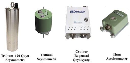
Equipment of Nanometrics Company of new 22 seismic stations
The main directions of the laboratory's scientific activity
1. Study of the seismic situation around volcanoes based on the data of established seismic stations.
2. Relationship of mud volcanoes with seismicity.
3. Determine the structure, depth, activation phases of volcanoes.
4. The relationship of volcanoes to faults.
5. Study of the tectonic structure of regions where mud volcanoes are located
It should also be noted that information is recorded from 12 cities of Turkey based on the Protocol of Agreement reached between the Department of Earthquakes of the Disaster and Emergency Management Presidency (AFAD) of the Ministry of Internal Affairs of the Republic of Turkey and the RSSC ANAS.
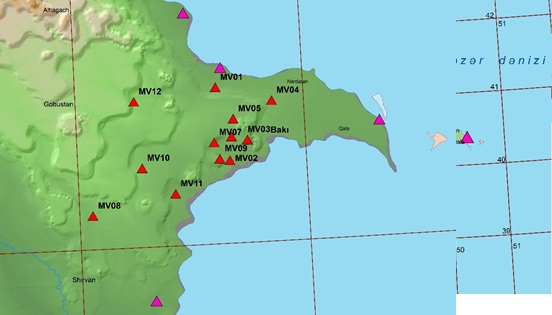
Network of seismic stations of mud volcanoes
1.3 International paleoseismological studies.
In 2021, negotiations on the creation of a mega-project on the study of active tectonics and paleoseismology, together with scientists from Oxford, Cambridge, California, Arizona and other universities, as well as leading specialists of BP and SOCAR oil companies, have begun. In April and May 2022, a group of five scientists led by Professor Richard Walker of the Department of Geology, Oxford, together with young scientists of the RSSC, carried out the first paleoseismological studies in the Agsu and Salyan area. The research used advanced technologies including satellite imagery, drone simulation, GPS and InSar technologies, seismic positioning and paleoseismic excavations. In Agsu, a trench was dug on the edge of the fault formed by the surface trace of the main overthrust fault of the Caucasus.
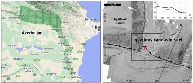
The location of the trench dug during paleoseismological research in Agsu region
Department of Engineering Geology and Seismic Microzoning
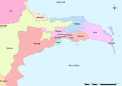 Based on engineering-geological and engineering-seismological data, seismic risk assessment, seismic microzoning works in the Absheron peninsula and each district of Greater Baku (Yasamal, Sabail, Khatai, Nasimi, Nizami, Narimanov, Garadagh, Binagadi, Surakhani, Sabunchu, Khazar, Absheron) regions and the construction of detailed seismicity maps for the city of Sumgait, and the creation of an information base based on ACCESS and ArcGIS programs.
 en
en  Az
Az  Ru
Ru